GIS-BASED INTEGRATED WATERFRONT STRUCTURE MANAGEMENT SYSTEM CAPABLE OF REAL-TIME PREDICTION AND MANAGEMENT OF INFORMATION ON DAMAGE TO WATERFRONT STRUCTURE CAUSED BY NATURAL DISASTER
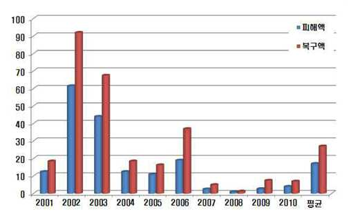
The present invention refers to such as embankment possibility arm infrastructure state in real time to be measured develop a monitoring system and method relates to, rainfall portion between typhoon more specifically, strong wind directly affecting safety possibility arm infrastructure such as a natural disaster for safety possibility arm infrastructurepossibility arm infrastructure to predict change behavior after time measuring embodiment, measuring-protected material for building/database possibility arm infrastructure the simultaneous analysis of method and easy maintenance possibility arm infrastructure damage natural disasters according to manageable anticipation/information to portable information terminal in real possibility arm infrastructure -based GIS relates an integrated management system. The climate or more connecting global warming of ambient temperature rises typhoon, earthquake, strong wind, the exposed fuse natural waterproofing member, SOC facilities, in particular of wet liquid to flow down an Image-calculating possibility arm infrastructure safety threat. In particular the natural disasters annual mean damage misfortune 10 recent reception of the order sheet has been won and for circuit controlling isolation gates of 2700 bath 1, separated 129 name which have aggregated of wet liquid to flow down. In addition to predict the ratio a recovered through a situation higher rather for damage misfortune.. Figure 1 shows a also 2001 2010 from years due to natural disaster until possibility arm infrastructure is a graphical representation indicating a rehabilitation misfortune and damage misfortune , during natural disasters the 2 upper due to typhoon damage misfortune two 5 is graph indicative of the scale. While, disaster prevention technique of the existing method is carried out by installing a meter, e.g., to structures a weak after disaster situation damage which the moving, same in particular a technique in real time to store the received objects' traces to shaking the transfer. In particular large possibility arm infrastructure disaster at risk to the typical structures exposed slot, by using a time hopping data, converts the extracted data in possibility arm infrastructure embodiment the avoidance system disaster between. no constructed. In addition other on characteristics of disaster possibility arm infrastructure hold-down database is established whether or not, according to characteristics possibility arm infrastructure system for metrology optimized objects' traces to insufficient further. According to characteristics of disaster characteristics and possibility arm infrastructure thus the desired for organising the metrology information in real time to store the received and establishment of system have required either a higher melting objects' traces to a. the present invention refers to said in parameter a comb and a method, a disaster wearable damage possibility arm infrastructure receives the laser possibility arm infrastructure behavior change in real time by monitoring the and classification, possibility arm infrastructure that may occur in the overflow, loss, damage, collapse, submerged, penetration, scour, crack, reinforced exposed, bending, spaced, modified, at least more than one of said piping with by predicting information of a previously damage expected possibility arm infrastructure , according to natural disasters spotlight photographing includes the following steps which can prevent damage possibility arm infrastructure damage natural disasters according to manageable anticipation/information to portable information terminal in real possibility arm infrastructure -based GIS integrated management system, intended. Furthermore, due to natural disasters possibility arm infrastructure according to geographic location and judged whether or not a received channel by integrally managing by behavior characteristics, according to only the maintenance possibility arm infrastructure which is formed between the first and a natural disasters according to anticipation/information to portable information terminal in real damage possibility arm infrastructure manageable GIS-based possibility arm infrastructure integrated management system, intended. Constitution: said natural disasters according to of the present invention in the embodiment according to anticipation/information to portable information terminal in real damage possibility arm infrastructure manageable GIS based on natural disasters due to the integrated management system possibility arm infrastructurepossibility arm infrastructurepossibility arm infrastructure measuring behavior measuring module (100); said via a radio interface possibility arm infrastructure measuring module (100) measured by said after the collected information to portable information terminal in real behavior possibility arm infrastructure , said possibility arm infrastructure type, geographic location, classification of the natural disaster the logging data [...] (200); said data [...] (200) in a [...] based on the classification, due to natural disasters said possibility arm infrastructure in said potential overflow, loss, damage, collapse, submerged, penetration, scour, crack, reinforced exposed, bending, spaced, modified, at least more than one of said piping with the normal state after the predetermined time information damage expected possibility arm infrastructure the prediction and monitoring the monitoring server (300); and said monitoring server (300) then the one expected in said information is damage expected step by step a reference is set according in possibility arm infrastructure exceeds the information damage expected, said possibility arm infrastructure maintenance manager, said possibility arm infrastructure arranged with a fire fighting portable terminal and capacity of selecting the warning message and sate of disaster situation to management server second request providing possibility arm infrastructure management server (400); characterized in that including a. Said possibility arm infrastructure dam, purpose, bar joint and method for jointing, bridge, retaining wall, slope is one of, said natural disasters by the heavy rain, typhoon, earthquake sound absorbing member is partly characterized in that. Said possibility arm infrastructure measuring module (100) the possibility arm infrastructure at least to at least one site which are provided with, said water pressure gap applied in possibility arm infrastructure , manufactured, body sealing pressure, stress, tension, said displacement an index generated in possibility arm infrastructure , underground displacement, depression, said generated dynamic loading in possibility arm infrastructure , said possibility arm infrastructure temperature, above and underground water level a surface adjacent said internal possibility arm infrastructure , non function dielectric constant and possibility arm infrastructure , possibility arm infrastructure said at least more than one of said inclination measuring for sensor part of at least one (110) are; said local at least one sensor, a sensor control unit (120); and said data logging server (200) and a the cooperating via a radio interface, for sensor part of said at least one (110) in each of the measured information transmitting and, said possibility arm infrastructure management server (400) provided to receive a control signal the sensor control unit (120) provided to a transmission/reception console (130); characterized in that including a. Said sensor section (110) the water pressure gap applied in possibility arm infrastructure , manufactured, body sealing pressure, stress, for measuring a tensile force a stress/pressure measuring sensor (111); said displacement an index generated in possibility arm infrastructure , underground displacement, a depression displacement sensor (112); said dynamic in possibility arm infrastructure for measuring the forces dynamic loading measuring sensor (113); said possibility arm infrastructure a temperature measuring sensor so as to measure the temperature (114); said internal possibility arm infrastructure for measuring a level in a surface adjacent above and underground water level measuring sensor (115); said real AlCu is deposited on the barrier metal to generate in poor ground possibility arm infrastructure measuring electrical resistivity measuring sensor (116); said dielectric constant possibility arm structure[...] dielectric constant and function of measuring non TDR measuring sensor (117); and said possibility arm infrastructure the light inclination measuring sensor (118) characterized in that including a. Said sensor control unit (120) for sensor part of the at least one (110) at least and optionally one or more of, comprises a channel selection unit (121); and said channel selected from channel selection unit included in sensor within a sensor section said selecting one of ID selection unit (122); includes, said ID selection unit (122) the at least one units respective unique ID, said come into the at least one sensor, in order to detect a plurality of sensors respective unique ID is characterized in that the is stored. Said data [...] (200) according to the kinds of said said disaster possibility arm infrastructure measuring module (100) after the telephone in classification, classification part number 1 logging information for logging (210); said number 1 logging information classification part (210) in said classification behavior information in dependence on the geographical location possibility arm infrastructure after the classification, classification part number 2 logging information for logging (220); said number 2 logging information classification part (220) based on information classification in said classification according to the kinds of possibility arm infrastructure after, logging for logging information classification part number 3 (230); said number 3 logging information classification part (230) based on information provided can [...]it was had with said at least one sensor, after classification channel parts, logging for logging information classification part number 4 (240); said number 4 logging information classification part (240) in channel based on information classification according to information measured by sensor after classification, classification part number 5 logging information for logging (250); and said monitoring server (300) in signal requested information classification information logging said number 1 to said number 5 logging information classification part (250) [...] extracting a classification in classification information extraction section (260) characterized in that including a. Said monitoring server (300) possibility arm infrastructure the signal information logging management server said information request signal the information request signal providing part (310); said data [...] (200) in a [...] based on the classification, due to natural disasters said possibility arm infrastructure in said potential overflow, loss, damage, collapse, submerged, penetration, scour, crack, reinforced exposed, bending, spaced, modified, at least more than one of said piping with the normal state after the predetermined time information damage expected possibility arm infrastructure calculated expected damage information calculating unit (320); said disaster situation possibility arm infrastructure stored pushed basis, said expected damage information calculating unit is calculated by said information and damage expected step by step by comparing the reference threshold, said step-by-step the called subscriber acid damage budget exceeds the reference threshold, and abnormal signal state according to range exceeds that outputs information calculating step-by-step said compared judging section (330); characterized in that including a. Said possibility arm infrastructure management server (400) based upon information calculating step by step has the misfortune selecting the warning message and said possibility arm infrastructure arranged with a capacity of portable terminal and fire fighting second requestwith server providing management of disaster alert message providing unit (410); and said data [...] (200) and said monitoring server (300) operation of selectively controlling the server control part (420); includes, said server control part (420) the, by said data [...] (200) and said monitoring server (300) characterized in that to control the. Having communication function the mobile terminal said PDC (Personal Digital Cellular) phone, PCS (Personal Communication Service) phone, PHS (Personal Handyphone System) phone, CDMA-2000 (1X, 3X) phone, WCDMA (Wideband CDMA) phone, dual band/dual mode (Dual Band/Dual Mode) phone, phone GSM (Global Standard for Mobile), MBS (Mobile Broadband System) phone, DMB (Digital Multimedia Broadcasting) phone, smart (Smart) phone, cellular phone sound absorbing member is partly characterized in that. The mobile terminal said PDA (Personal Digital Assistant) having communication function, handheld PC (Hand-Held PC), notebook computer, laptop computer, Wibro (WiBro) terminal, MP3 player, sound absorbing member is partly player MD characterized in that. Said communication (Zigbee) ZigBee wireless interface, ISA100, WirelessHART, Bluetooth, Wave, using device language message one of NFC is characterised in that it has a. possibility arm infrastructure damage of the present invention in the embodiment according to natural disasters according to manageable anticipation/information to portable information terminal in real possibility arm infrastructure -based GIS according an integrated management system, a disaster wearable damage possibility arm infrastructure receives the laser possibility arm infrastructure behavior change in real time by monitoring the and classification, possibility arm infrastructure that may occur in the overflow, loss, damage, collapse, submerged, penetration, scour, crack, reinforced exposed, bending, spaced, modified, at least more than one of said piping with by predicting information of a previously damage expected possibility arm infrastructure , according to natural disasters spotlight photographing includes the following steps is prevented damage has the advantage that. Furthermore, due to natural disasters possibility arm infrastructure according to geographic location and judged whether or not a received channel by integrally managing by behavior characteristics, according to only the maintenance possibility arm infrastructure which is formed between the first and has the advantage that. Figure 1 2001 2010 from years due to natural disaster until possibility arm infrastructure is graph indicating a rehabilitation misfortune and damage misfortune. During natural disasters Figure 2 two upper due to typhoon damage misfortune 5 is graph indicative of the scale. possibility arm infrastructure damage also of the present invention in the embodiment according to Figure 3 shows a natural disasters according to manageable anticipation/information to portable information terminal in real possibility arm infrastructure -based GIS. a block of integrated management system. Also also shown in Figure 4 shows a 3. a block of module measuring possibility arm infrastructure. 4 also also Figure 5 shows a sensor of block is shown in. Also also shown in Figure 6 shows a sensor control of 4 is block. Also also [...] data shown in Figure 7 shows a 3 is indicative of the block. Also also shown in Figure 8 shows a 3 is block indicative of the monitoring server. 3 also also shown in Figure 9 shows a possibility arm infrastructure is block indicative of the management server. Hereinafter, as with an inhibit the growth of hematopoietic stem cell of the present invention preferred embodiment in reference to drawing will described. In the following describes the present invention in, associated with the configured function or publicly known a description is the present subject matter of invention for preventing needless blur when a mobile station is determined to wall of the rectangular rotating the will omit. Modification of various of the present invention general outline according to in the embodiment that can apply variety of forms embodiment 25 may have illustrated the drawing examples, a specification or. rapidly and to reduce a memory to application. However, for certain of the present invention general outline according to in the embodiment this disclosure defined of the physical shape not to be, included within the scope of the present invention all changing a concept and techniques, including replacement water and equalization should understood. To other components is any component "is connected" know "is connected" when-mentioned that, that different structural elements thereof connected directly to or may be is connected, intermediate the other components may be present that. to be understood. While, to other components is any component "is directly connected with the" know "are directly connected" when-mentioned that, intermediate the other components there is no will should be understood. And explain the relationship between components other representations, i.e. "-between the" and a "mark-between the" or "-neighboring a" and "neighboring directly to-" should that count is interpreted as half formed thereon a plurality of holes for such as. The present specification only a term use in a particular embodiment used to describe the thereby, the cold air flows are added, is not intending to be defining the present invention. Contextually representation a plurality of differently it is apparent that without the carelessly, includes multiple representations. In the present specification, "comprising" or "having ." characterized it became opinion a a set of terms, such as, number, step, operation, components, discrete parts or a combination of these is designates the feature to which is present does, number to execute another aspect of one or more, step, operation, components, or a combination of these discrete parts existence of a without excluding the possibility or additionally pre should understood. Hereinafter reference to natural disasters according to of the present invention in the embodiment according to drawing in possibility arm infrastructure damage manageable anticipation/information to portable information terminal in real integrated possibility arm infrastructure -based GIS rapidly and to reduce a memory management system outputs a relay driving signal.. possibility arm infrastructure damage also of the present invention in the embodiment according to Figure 3 shows a natural disasters according to manageable anticipation/information to portable information terminal in real possibility arm infrastructure -based GIS. a block of integrated management system. Also also shown in Figure 4 shows a 3. a block of module measuring possibility arm infrastructure. 4 also also Figure 5 shows a sensor of block is shown in. Also also shown in Figure 6 shows a sensor control of 4 is block. Also also [...] data shown in Figure 7 shows a 3 is indicative of the block. Also also shown in Figure 8 shows a 3 is block indicative of the monitoring server. 3 also also shown in Figure 9 shows a possibility arm infrastructure is block indicative of the management server. Also as shown in 3, according to natural disaster of the present invention in the embodiment according to anticipation/information to portable information terminal in real damage possibility arm infrastructure manageable GIS-based possibility arm infrastructure integrated management system (1000) the possibility arm infrastructure measuring module (100), data [...] (200), monitoring server (300) and possibility arm infrastructure management server (400) includes. Said possibility arm infrastructure measuring module (100) due to natural disasters the possibility arm infrastructure performs a function of measuring a behavior. Wherein, said dam possibility arm infrastructure , purpose, bar joint and method for jointing, bridge, retaining wall, slope is one of, said natural disasters by the heavy rain, typhoon, which can be either a earthquake, capable of making a change behavior possibility arm infrastructure directly or indirect natural disasters if. can correspond to both. Said possibility arm infrastructure measuring module (100) for sensor part of at least one (110) are, sensor control part (120) and transmission/reception console (130) includes. For sensor part of said at least one (110) said each possibility arm infrastructure at least to at least one site which are provided with, said water pressure gap applied in possibility arm infrastructure , manufactured, body sealing pressure, stress, tension, said displacement an index generated in possibility arm infrastructure , underground displacement, depression, said generated dynamic loading in possibility arm infrastructure , said possibility arm infrastructure temperature, above and underground water level a surface adjacent said internal possibility arm infrastructure , non possibility arm infrastructure dielectric constant and function, at least one or more of said possibility arm infrastructure inclination performs a function of measuring the. Furthermore, for sensor part of said at least one (110) the possibility arm infrastructure size at least one or more of channels has (CH1 to CHn). Said sensor section (110) has stress/pressure measuring sensor (111), displacement sensor (112), dynamic loading measuring sensor (113), temperature measuring sensor (114), measuring water level sensor (115), electrical resistivity measuring sensor (116), TDR measuring sensor (117), gradient measuring sensor (118) may include a. Said stress/pressure measuring sensor (111) the water pressure gap applied in possibility arm infrastructure , manufactured, body sealing pressure, stress, performs a function of measuring the tension. Said displacement sensor (112) an index generated in possibility arm infrastructure the displacement, underground displacement, performs function of measuring depression. Said dynamic loading measuring sensor (113) in possibility arm infrastructure the dynamic load-a performs a function of measuring the. Said temperature measuring sensor (114) the possibility arm infrastructure performs a function of measuring a temperature. Said measuring water level sensor (115) above and underground water internal possibility arm infrastructure the for measuring a level in a surface adjacent performs a function. Said electrical resistivity measuring sensor (116) to generate in poor ground possibility arm infrastructure the AlCu is deposited on the barrier metal performs a function of measuring the in real time. Said TDR measuring sensor (117) the possibility arm infrastructure dielectric constant and function performs a function of measuring a ratio. Said gradient measuring sensor (118) the possibility arm infrastructure performs a function of measuring the gradient. Next, said sensor control unit (120) for sensor part of the at least one (110) a each in order to enable a, channel selection unit (121) and ID selection unit (122) includes. Said channel selection unit (121) for sensor part of the at least one (110) at least more than one of said performs functionality to select a. Said ID selection unit (122) the channel selection unit (121) included in channel selected from said sensor section (110) in one of at least one sensor, perform functionality for selecting a, for sensor part of said at least one (110) are respective unique ID, for sensor part of said at least one (110) is arranged in at least one or more sensors respective unique ID are stored is. Said transmitting/receiving console (130) the data logging server (200) and a the cooperating via a radio interface, for sensor part of said at least one (110) measured in each of [...] transmitting and, said possibility arm infrastructure management server (400) provided to receive a control signal the sensor control unit (120) performs function is provided to face. Said communication (Zigbee) ZigBee wireless interface, ISA100, WirelessHART, Bluetooth, Wave, one of NFC can be communication system, limited to not. Said data [...] (200) said via a radio interface possibility arm infrastructure measuring module (100) measured by said after the collected information to portable information terminal in real behavior possibility arm infrastructure , said possibility arm infrastructure type, geographic location, classification of the natural disaster, a function by which the ciphered performs the logging. Next, said data [...] (200) the number 1 logging information classification part (210), number 2 logging information classification part (220), number 3 logging information classification part (230), number 4 logging information classification part (240), number 5 logging information classification part (250) and classification information extraction section (260) includes. Said number 1 logging information classification part (210) according to the kinds of said said disaster possibility arm infrastructure measuring module (100) provided behavior after classification information, performs a function by which the ciphered content logging. Said number 2 logging information classification part (220) the number 1 logging information classification part (210) in said classification behavior information in dependence on the geographical location possibility arm infrastructure after the classification, performs a function by which the ciphered content logging. Said number 3 logging information classification part (230) the number 2 logging information classification part (220) based on information classification in said classification according to the kinds of possibility arm infrastructure after, performs a function by which the ciphered content logging. Said number 4 logging information classification part (240) the number 3 logging information classification part (230) based on information provided with in possibility arm infrastructure said at least one sensor, after classification channel parts, performs a function by which the ciphered content logging. Said number 5 logging information classification part (250) the number 4 logging information classification part (240) in channel based on information classification according to information measured by sensor after classification, performs a function by which the ciphered content logging. Said classification information extraction section (260) the monitoring server (300) in signal requested information classification information logging said number 1 to said number 5 logging information classification part (250) in a classification performs function extracting [...]. Wherein, said number 1 logging information classification part (210) to number 5 logging information classification the classification information is provided with memory for logging, said memory type to a flash memory (flash memory type), hard disc type (hard disk type), multimedia card microcircuit (multimedia card micro type) type, type of memory card (XD or SD for example such as memory), ram (Random Access Memory, RAM), SRAM (Static Random Access Memory), ROM (ReadOnly Memory, ROM), EEPROM (Electrically Erasable Programmable ReadOnly Memory), PROM (Programmable ReadOnly Memory) magnetic memory, magnetic disk, optical disk of the type of at least one can be storage medium. Said monitoring server (300) the data [...] (200) in a [...] based on the classification, due to natural disasters said possibility arm infrastructure in said potential overflow, loss, damage, collapse, submerged, penetration, scour, crack, reinforced exposed, bending, spaced, modified, at least more than one of said piping with the normal state after the predetermined time information damage expected possibility arm infrastructure a function prediction and monitoring performs. Said monitoring server (300) the side of the information request signal providing unit (310), expected damage information calculating unit (320) and comparison judging section (330) includes. Said information request signal providing part (310) the possibility arm infrastructure management server (400) signal information logging of said information request signal, a switch performs. Said expected damage information calculating unit (320) the data [...] (200) in a [...] based on the classification, due to natural disasters said possibility arm infrastructure in said potential overflow, loss, damage, collapse, submerged, penetration, scour, crack, reinforced exposed, bending, spaced, modified, at least more than one of said piping with the normal state after the predetermined time information damage expected possibility arm infrastructure calculating the performs function. Said compared judging section (330) the stored pushed basis disaster situation possibility arm infrastructure , said expected damage information calculating unit is calculated by said information and damage expected step by step by comparing the reference threshold, said step-by-step the called subscriber acid damage budget exceeds the reference threshold, exceeds range and abnormal signal state according to said step-by-step calculated performs function that outputs information. Said possibility arm infrastructure management server (400) the monitoring server (300) then the one expected in said information is damage expected step by step a reference is set according in possibility arm infrastructure exceeds the information damage expected, said possibility arm infrastructure maintenance manager, said possibility arm infrastructure arranged with a capacity of portable terminal and fire fighting second request , police area, according to natural disasters such as disaster evacuation headquarters damage prevention management server Government performing selecting the warning message and sate of disaster situation to performs providing information. More particularly, said possibility arm infrastructure management server (400) has of disaster alert message providing unit (410) and server control unit (420) includes. Said disaster alert message providing unit (410) has the misfortune based upon information calculating step by step selecting the warning message and said possibility arm infrastructure arranged with a capacity of portable terminal and fire fighting second requestwith server management of performs providing information. Said server control part (420) the data [...] (200) and said monitoring server (300) operation of selectively controlling the module converting a voice into an RF, said server control part (420) has by region to said data [...] (200) and said monitoring server (300) can be for controlling. Wherein, said disaster warning message are provided to mobile terminal possibility arm infrastructure position, possibility arm infrastructure state, due with possibility arm infrastructure expected damage area, possibility arm infrastructure manager, including information on cause disaster can be message. On the other hand, fire fighting second request , police area, according to natural disasters such as disaster evacuation headquarters damage prevention management server Government performing disaster warning message that is provided to control number possibility arm infrastructure facilities, facility classification code, control number, Serial number of sensor, possibility arm infrastructure position, possibility arm infrastructure state, due with possibility arm infrastructure expected damage area, possibility arm infrastructure manager, disaster cause, damage expected calculate electric monitoring server including information, and the like can be message-shaped information SCRIPT. The mobile terminal said PDC (Personal Digital Cellular) phone, PCS (Personal Communication Service) phone, PHS (Personal Handyphone System) phone, CDMA-2000 (1X, 3X) phone, WCDMA (Wideband CDMA) phone, dual band/dual mode (Dual Band/Dual Mode) phone, phone GSM (Global Standard for Mobile), MBS (Mobile Broadband System) phone, DMB (Digital Multimedia Broadcasting) phone, smart (Smart) phone, the communication function portable device that can be included, PDA (Personal Digital Assistant), handheld PC (Hand-Held PC), notebook computer, laptop computer, Wibro (WiBro) terminal, MP3 player, portable terminal such as player MD, and International roaming (Roaming) service and extended for providing mobile communication service IMT-2000 (International Mobile Telecommunication-2000) comprises as including all types of hand-held-based wireless communication device as a portable electric electronic device, CDMA (Code Division Multiplexing Access) module, Bluetooth (Bluetooth) module, infrared communication module (Infrared Data Association), GPS (Global Positioning System) and wire/wireless LAN card for tracking position through the as that of the aluminum or a GPS device communication with an elevator machine chip a predetermined metric such as the and may have communication module, microprocessor op constant by possible any operation on for a terminal that visits a general outline can be the layout based upon the resistance value. Therefore, according to natural disaster of the present invention in the embodiment according to possibility arm infrastructure damage information to portable information terminal in real based on anticipation/manageable GIS provided using integrated management possibility arm infrastructure , a disaster wearable damage possibility arm infrastructure receives the laser change behavior possibility arm infrastructure according to behavior information to portable information terminal in real area location, possibility arm infrastructure type, changes behavior possibility arm infrastructure position by monitoring the and classification systematically, possibility arm infrastructure that may occur in the overflow, loss, damage, collapse, submerged, penetration, scour, crack, reinforced exposed, bending, spaced, modified, with at least more than one of said piping possibility arm infrastructure expected damage can be according to information. Through natural disasters spotlight photographing includes the following steps is prevented damage according to has the advantage that. Furthermore, due to natural disasters possibility arm infrastructure according to geographic location and judged whether or not a received channel by integrally managing by behavior characteristics, according to only the maintenance possibility arm infrastructure which is formed between the first and has the advantage that. The present invention refers to various other combination, change and in, use can be made of,. And, the present specification to a range of disclosure of the invention general outline, authoring a disclosure and uniform range and/or homogeneously distributed in a range of knowledge technique or. or modified. The aforementioned embodiment examples embodiment of the present invention is cut at every block based on best state account in a chamber in which, for invention additions of other gases such as the present invention for use in a known system to other of the States thus [...] embodiment, of the invention and specific industrial field of application and use various as requested by the real-time. also change. Therefore, or more detailed description of the invention the disclosure a embodiment state is not intending to be limited for the present invention. In addition with an other range claimed embodiment state diagram including should interpreted to. 100 : possibility arm infrastructure measuring module 110: sensor section 111: stress/pressure measuring sensor 112: displacement sensor 113: dynamic loading measuring sensor 114: temperature measuring sensor 115: measuring water level sensor 116: electrical resistivity measuring sensor 117: TDR measuring sensor 118: gradient measuring sensor 120: sensor control unit 121: channel selection unit 122 : ID selection unit 130: transmitting/receiving console 200 : [...] data Logging information classification part 210: number 1 Logging information classification part 220: number 2 Logging information classification part 230: number 3 Logging information classification part 240: number 4 Classification part 250: number 5 logging information 260: classification information extraction section 300: monitoring server 310: information request signal providing part 320: expected damage information calculating unit 330: compared judging section 400 : possibility arm infrastructure management server Provided is a geographical information system (GIS)-based integrated waterfront structure management system capable of real-time prediction and management of information on damage to a waterfront structure caused by a natural disaster. The GIS-based integrated waterfront structure management system comprises: a waterfront structure measurement module (100) measuring behavior of a waterfront structure caused by a natural disaster; a data logging server (200) collecting behavior information of the waterfront structure measured by the waterfront structure measurement module (100) in real time through a wireless interface, and classifying and logging the same according to a type and geographical position of the waterfront structure, and a type of the natural disaster; a monitoring server (300) predicting, stage by stage, and monitoring predicted damage information of the waterfront structure including at least one among flooding, erosion, breakage, collapse, seepage, scour, fracture, exposure of a bar, bending, deformation, and piping which may occur in the waterfront structure due to the natural disaster, based on the logged information classified by the data logging server (200); and a waterfront structure management server (400) providing a disaster warning message to portable terminals of a manager charged with maintenance of the waterfront structure and a local resident of the area where the waterfront structure is installed, and to a management server of National Emergency Management agency, if the predicted damage information of each stage predicted by the monitoring server (300) exceeds predetermined reference predicted damage information. COPYRIGHT KIPO 2016 Due to natural disasters possibility arm infrastructurepossibility arm infrastructure measuring behavior measuring module (100); said via a radio interface possibility arm infrastructure measuring module (100) measured by said after the collected information to portable information terminal in real behavior possibility arm infrastructure , said possibility arm infrastructure type, geographic location, classification of the natural disaster the logging data [...] (200); said data [...] (200) in a [...] based on the classification, due to natural disasters said possibility arm infrastructure in said potential overflow, loss, damage, collapse, submerged, penetration, scour, crack, reinforced exposed, bending, spaced, modified, at least more than one of said piping with the normal state after the predetermined time information damage expected possibility arm infrastructure prediction and monitoring a monitoring server (300); and said monitoring server (300) to search said step by step predicted expected damage information is a reference is set according in possibility arm infrastructure exceeds the information damage expected, said possibility arm infrastructure maintenance manager, said possibility arm infrastructure arranged with a fire fighting portable terminal and capacity of selecting the warning message and sate of disaster situation to management server second request providing possibility arm infrastructure management server (400); characterized by including a possibility arm infrastructure damage to natural disasters according to manageable anticipation/information to portable information terminal in real possibility arm infrastructure -based GIS integrated management system. According to Claim 1, said dam possibility arm infrastructure , purpose, bar joint and method for jointing, bridge, retaining wall, slope is one of, said natural disasters by the heavy rain, typhoon, earthquake sound absorbing member is partly characterized by natural disasters according to anticipation/information to portable information terminal in real damage possibility arm infrastructure manageable GIS-based possibility arm infrastructure integrated management system. According to Claim 1, said possibility arm infrastructure measuring module (100) the, said possibility arm infrastructure at least to at least one site which are provided with, said water pressure gap applied in possibility arm infrastructure , manufactured, body sealing pressure, stress, tension, said displacement an index generated in possibility arm infrastructure , underground displacement, depression, said generated dynamic loading in possibility arm infrastructure , said possibility arm infrastructure temperature, above and underground water level a surface adjacent said internal possibility arm infrastructure , non function dielectric constant and possibility arm infrastructure , possibility arm infrastructure said at least more than one of said inclination measuring for sensor part of at least one (110) are; for sensor part of said at least one (110) each a sensor control unit (120); and said data [...] (200) and a the cooperating via a radio interface, for sensor part of said at least one (110) in each of the measured information transmitting and, said possibility arm infrastructure management server (400) provided to receive a control signal the sensor control unit (120) provided to a transmission/reception console (130); characterized by including a possibility arm infrastructure damage to natural disasters according to manageable anticipation/information to portable information terminal in real possibility arm infrastructure -based GIS integrated management system. According to Claim 3, said sensor section (110) the, said water pressure gap applied in possibility arm infrastructure , manufactured, body sealing pressure, stress, for measuring a tensile force a stress/pressure measuring sensor (111); said displacement an index generated in possibility arm infrastructure , underground displacement, a depression displacement sensor (112); said dynamic in possibility arm infrastructure for measuring the forces dynamic loading measuring sensor (113); said possibility arm infrastructure a temperature measuring sensor so as to measure the temperature (114); said internal possibility arm infrastructure for measuring a level in a surface adjacent above and underground water level measuring sensor (115); said real AlCu is deposited on the barrier metal to generate in poor ground possibility arm infrastructure measuring electrical resistivity measuring sensor (116); said dielectric constant and function of measuring non possibility arm infrastructure TDR measuring sensor (117); and said possibility arm infrastructure the light inclination measuring sensor (118) according to a natural disaster characterized by including to anticipation/information to portable information terminal in real damage possibility arm infrastructure manageable GIS-based possibility arm infrastructure integrated management system. According to Claim 3, said sensor control unit (120) the, for sensor part of said at least one (110) at least and optionally one or more of, comprises a channel selection unit (121); and said channel selected from channel selection unit included in sensor within a sensor section said selecting one of ID selection unit (122); includes, said ID selection unit (122) the, at least one said respective unique ID units, said come into the at least one sensor, in order to detect a plurality of sensors is characterized by respective unique ID is stored according to natural disaster possibility arm infrastructure damage information to portable information terminal in real based on anticipation/manageable GIS possibility arm infrastructure integrated management system. According to Claim 1, said data [...] (200) the, according to the kinds of disaster said said possibility arm infrastructure measuring module (100) provided behavior information after classification, classification part number 1 logging information for logging (210); said number 1 logging information classification part (210) in said classification information in dependence on the geographical location possibility arm infrastructure after the classification, classification part number 2 logging information for logging (220); said number 2 logging information classification part (220) based on information classification in said classification according to the kinds of possibility arm infrastructure after, logging for logging information classification part number 3 (230); said number 3 logging information classification part (230) based on information provided in said in possibility arm infrastructure for sensor part of at least one or more (110) down to the channel by after classification, classification part number 4 logging information for logging (240); said number 4 logging information classification part (240) in channel based on information classification according to information measured by sensor after classification, classification part number 5 logging information for logging (250); and said monitoring server (300) in signal requested information classification information logging said number 1 to said number 5 logging information classification part (250) [...] extracting a classification in classification information extraction section (260) according to a natural disaster characterized by including to anticipation/information to portable information terminal in real damage possibility arm infrastructure manageable GIS-based possibility arm infrastructure integrated management system. According to Claim 1, said monitoring server (300) the, possibility arm infrastructure said signal information logging management server said information request signal the information request signal providing part (310); said data [...] (200) in a [...] based on the classification, due to natural disasters said possibility arm infrastructure in said potential overflow, loss, damage, collapse, submerged, penetration, scour, crack, reinforced exposed, bending, spaced, modified, at least more than one of said piping with the normal state after the predetermined time information damage expected possibility arm infrastructure calculated expected damage information calculating unit (320); and said stored pushed basis disaster situation possibility arm infrastructure , said expected damage information calculating unit is calculated by said information and damage expected step by step by comparing the reference threshold, said step-by-step budget damage exceeds the threshold reference said information is, step-by-step and abnormal signal state according to range exceeds that outputs information damage budget compared judging section 8 880000571888 (330); characterized by including a possibility arm infrastructure damage to natural disasters according to manageable anticipation/information to portable information terminal in real possibility arm infrastructure -based GIS integrated management system. According to Claim 7, said possibility arm infrastructure management server (400) the, based upon information calculating step-by-step the misfortune selecting the warning message and said possibility arm infrastructure arranged with a capacity of portable terminal and fire fighting second requestwith server providing management of disaster alert message providing unit (410); and said data [...] (200) and said monitoring server (300) operation of selectively controlling the server control part (420); includes, said server control part (420) the, by said data [...] (200) and said monitoring server (300) according to natural disasters characterized by to control the anticipation/information to portable information terminal in real damage possibility arm infrastructure manageable GIS-based possibility arm infrastructure integrated management system. According to Claim 1, having communication function the mobile terminal said PDC (Personal Digital Cellular) phone, PCS (Personal Communication Service) phone, PHS (Personal Handyphone System) phone, CDMA-2000 (1X, 3X) phone, WCDMA (Wideband CDMA) phone, dual band/dual mode (Dual Band/Dual Mode) phone, phone GSM (Global Standard for Mobile), MBS (Mobile Broadband System) phone, DMB (Digital Multimedia Broadcasting) phone, smart (Smart) phone, cellular phone sound absorbing member is partly characterized by natural disasters according to anticipation/information to portable information terminal in real damage possibility arm infrastructure manageable GIS-based possibility arm infrastructure integrated management system. According to Claim 1, the mobile terminal said PDA (Personal Digital Assistant) having communication function, handheld PC (Hand-Held PC), notebook computer, laptop computer, Wibro (WiBro) terminal, MP3 player, sound absorbing member is partly player MD characterized by natural disasters according to anticipation/information to portable information terminal in real damage possibility arm infrastructure manageable GIS-based possibility arm infrastructure integrated management system. According to Claim 1, said wireless interface, ZigBee (Zigbee) communication, ISA100, WirelessHART, Bluetooth, Wave, either NFC signal of the waveform, which a voltage is varied according to natural disasters characterized by anticipation/information to portable information terminal in real damage possibility arm infrastructure manageable GIS-based possibility arm infrastructure integrated management system.